Frequently Asked Questions
Implementing EMSA
MERIT is an abbreviation for Monitoring Evaluation Reporting and Improvement Tool. It is the Department of Climate Change, Energy, the Environment and Water managed online reporting tool. MERIT is designed to collect and store planning, monitoring and reporting data associated with natural resource management grants projects funded by the Australian Government. MONITOR is where the project planning and selection of EMSA modules takes place. When module selection is completed and approved, they will be visible in MONITOR Staging and MONITOR Production.
In the first instance, the RDP decides which
modules seem the most applicable to the needs of their project(s). Module
choices are informed by project outcomes, selected project services and field monitoring
requirements. There are also various guidance documents and tools to assist RDPs
in the module selection process.
These include:
- the EMSA decision support guidance material (pdf)
- the EMSA module description table (xls)
- a template for EMSA module selection and TEC case study (ppt)
- the EMSA module selector (web app).
RDPs can also get in touch with their DCCEEW contract manager, the DCCEEW Long-term monitoring team (via ltmp@dcceew.gov.au) or the EMSA support helpdesk.
The different protocols capture different levels of detail and commit different amounts of field time. Deciding which protocol(s) to use depends on your project's needs and monitoring plan. For example, some projects might consider including more detailed protocols (‘enhanced’ protocols) in the project's first year and final year and rely on less detailed protocols (‘standard’ protocols) for years two or three.
EMSA does not currently have a module designed for drone-collected data. However, this may change in the future. For now, it is suggested RDPs use the Targeted Surveys Module to document what monitoring is being done, how it is collected, and where the data is held.
The EMSA manuals are available to use now.
However, access to Monitor requires you to have a MERIT account that has been assigned a role in the specific project/s that you will be working on. Additionally, Regional Delivery Partners must have submitted a MERI plan(s) in
MERIT. The modules you select in your MERI plan (under monitoring methodology) will
then be migrated to Monitor.
CoPs are Community of Practice meetings. They are an opportunity to share updates about EMSA, MERIT, MONITOR, and the Long Term Monitoring Program. CoPs are primarily designed for Regional Delivery Partners to ask questions and provide feedback to both DCCEEW and TERN. CoPs may be themed, and involve a brief presentation to promote discussion.
To be added to the invite list for future EMSA CoPs please contact the Long Term Monitoring Program team at DCCEEW at LTMP@dcceew.gov.au
You can also access recordings of past EMSA CoPs on the Events and Webinars page of this website.
Using Monitor
Anyone who is affiliated with an Australian Government NRM investment project that is registered in MERIT is eligible for access to Monitor. Third parties can either be registered for that project as a nominated project officer or as a contractor. If nominated as a project officer, they will have full access to that project in MERIT, including read/write permissions. If nominated as a contractor, they will be able to access the required modules in Monitor, and submit the collected data, but not be able to access those projects in MERIT.
We hope to make the app accessible to a broader
user base in the future, however at this stage only
projects that are registered in
MERIT, principally Regional Delivery Partners (RDPs), and their sub-contractors
are our user base. We use RDP to refer to this first user set.
A demo version of Monitor was released to invited Regional Delivery Partners March-April 2024.
Details on accessing both the Staging version of Monitor (test environment) and the full version of Monitor were released to Regional Delivery Partners at the May 2024 CoP meeting. If you are a Regional Delivery Partner, and have not yet received information on accessing Monitor, please contact us.
Monitor works best on Android devices and
computers using Google Chrome. Desktop/laptop computers, mobiles and tablets
can all be used. iOS software (Apple
iphones and ipads) is not supported. Please ensure that the device location is
enabled to avoid pop-up errors. Monitor will use the device camera to take
photos and sound recordings and access photos and sound files from the device
or computer.
We recommend you use Monitor on Android devices that are no older than 5 years, and that you keep your device up to date with the most recent system updates.
Our Monitor development testing is undertaken on the Samsung Galaxy Tab S6 Lite and the Samsung Galaxy Active 5. We recommend the specifications of your device are at least that of the S6 Lite.
As devices age, they often experience performance issues when using apps and performing general functions. The Monitor app is no exception.
Device hardware such as processors, storage and batteries degrade over time and older devices will become sluggish and can struggle managing data. Because of this, older devices using Monitor may have difficulty submitting surveys and result in sync errors, or become very slow when using other functions within the Monitor App. It can be very difficult to resolve these issues on older devices as they cannot always perform the actions we need to extract data and could result in data loss.
The Monitor Staging app is a copy of the real (Production) Monitor app, built for training and practice purposes. You can use the Staging app to enter test data from mock surveys, to help you become familiar with the app and how it works before you go into the field and use the Production Monitor app. Anything put into the Staging app will be wiped and refreshed every Sunday – so never put your real data into staging.
Because the Staging app refreshes on a Sunday, if the project has only been added to Monitor in the last few days, you will need to wait until Sunday for it to refresh again. Login is using MERIT credentials.
The real Monitor App (production version) connects to the Australian Government's Biodiversity Data Repository (BDR), where all the data you collect in the field will be stored. Login is using MERIT credentials.
Monitor has been verified to work on Samsung Tab S6 Lite tablets, and should be compatible with Samsung S-series tablets released after 2020 (e.g. Tab S7, S8 etc). Our more recent (2024) field trials have been conducted using Samsung Tab Active 5 tablets. As Monitor is rolled-out and used on a wider variety of devices, we will add to the list of recommended devices.
Devices that do not have mobile data (i.e. no SIM card
and are WiFi only) will need to be on a network before field surveys are
conducted to set up the modules/available data correctly and after field
surveys to upload data to the server. Instructions on preparing for offline
work will be released soon.
Using a field collection app has many benefits, including saving
time as data is entered directly in the field, and there is no need to
transcribe hand-written datasheets (which also comes with readability errors).
The app also restricts data to the pick-lists (drop-down options), or data type
(i.e. text and numbers) within a certain range or restrictions so that all data
entered must meet specific criteria. For example, a tree cannot be 220 m tall,
a shrub cannot be 27 m tall but a tree can. Restricting the data to pick-lists
helps standardise the data to accepted terms (i.e. definitions and terms of the
EMSA vocabularies and the Australian Biological Information Standard.
Datasheets designed to match the EMSA modules and Monitor app workflows have been created and are available to download from this website shortly (see Download Documents). Regional Delivery Partners will be responsible for manually entering data into Monitor.
Data will be saved on the device as you progress through the survey. It will remain on the device until the device is queued to sync the collection with the Cloud.
Once the device has synced, you will be notified in the Monitor app (a pop-up will appear). The dataset summary will also be visible in MERIT.
The staging
site is wiped every Sunday evening and we are not able to reload lost data. To
keep practicing on the staging platform you will need to input more mock data.
If you are using real data that you would like to save then this should
be done on the production platform.
Training
TERN will provide up to four on-ground training programs each year from 2024 to 2028. The on-ground course curriculum and program are currently being developed and are likely to be run over 3-4 consecutive days in regional locations (locations are yet to be determined). The on-ground training will focus on hands-on practical demonstrations. More information on the training can be found on this website soon. We will be calling for registrations of interest to assist with identifying course locations and date options.
In addition to the on-ground training courses, other types of training and support will be available soon, including webinars, “community of practice” online forums and workshops.
We will also be loading up more instructional videos including Monitor screen captures for selected modules and actions.
Training is available to anyone with a formal affiliation with RDP projects. Sub-contractors are welcome to attend, however will need the approval of the Regional Delivery Partner affiliated with a project.
Data Access and Security
Monitor data will be stored in the Australian Government’s Biodiversity Data Repository (BDR) and made accessible to RDPs via a link in MERIT. A data download button should be available from the Data Summary tab soon. In the interim, RDPs can view a summary of any data they have collected using Monitor, under the Data Summary tab in MERIT.
Yes. BDR’s systems and data will conform with all expected cybersecurity measures to ensure your data will be secure from unauthorised access and use.
Initially, only RDP project administrators,
DCCEEW contract managers and the DCCEEW BDR team will have access to data
collected through Monitor. Ultimately however, the intention is that all non-sensitive
BDR data will be made publicly available through a data access portal. At the
moment, there is no date set for that function to become available and there
will be consultation with RDPs before that feature is turned on.
Sensitive data may include precise locations of species
and ecological communities that could be placed at high risk if their locations
are known, and location data that is culturally or otherwise considered sensitive.
The BDR will generalise sensitive data (by, for example, replacing precise
locations with 10km x 10 km grid squares). RDPs will need to contact the
Department by emailing ltmp@dcceew.gov.au
to discuss any sensitive data restrictions.
No. Data collected using Monitor does not need
to be submitted separately to DCCEEW.
Once the download link is up and running through MERIT, RDPs are free to share a copy of the download with state/territory agencies. State and territory governments are also working closely with the Commonwealth BDR team and will be able to extract a copy of the data in the future, or link directly to the data from the BDR.
As per the RDP Header Agreement, the Australian Government owns the Intellectual Property of any on-ground data it has paid for through the Natural Heritage Trust RDP program. Sensitive data will be managed as described above, which includes provisions for threatened species ecological communities and culturally sensitive locations. Private land holder data will be considered as part of the above, and additional factors may be taken into account. Ultimately however, any data that is stored in the BDR will be accessible by the Australian Government as a minimum requirement. If a landholder is uncomfortable with this arrangement, then the data has little value to the Australian Government. Where the private landholder will not consent to sharing data with the Australian Government, the RDP should consider working elsewhere.
The Australian Government needs good data to
inform policy, track environmental change, and increase understanding of NRM
investments
There are validation checks built into the
Monitor app which constrain data entry into what is biologically possible. The
BDR will also apply quality assurance checks to the data, for example to detect
outliers that may comprise misidentifications of species.
The BDR team can be contacted via bdr@dcceew.gov.au
To access the Monitor app, users will require a MERIT account. As an RDP Project Manager, you can add users to your project(s) in the Admin tab under Project Access. The ‘Field data collector’ user role can use the Monitor app but cannot see or edit project information.
Once the data download link is up and running
through MERIT, RDPs will have access to any data they have collected via
Monitor. They can then use/analyse the data as they see fit, including
conducting a quality assurance (QA) check (as they may have done in the past,
under previous programs). It is up to the RDP to decide how they want to manage
their QA processes in-house.
Data Analysis
No. Reporting on project outcomes is the responsibility of the RDP. Any analysis of individual monitoring datasets undertaken by DCCEEW will focus on the achievement of program level outcomes. Note, however, that BDR data as a whole (aggregated from many sources) support analyses undertaken regularly by DCCEEW to, for example, assess the status of species and model their distributions.
Analyses by others of your specific datasets is
unlikely in the immediate future. Our current priority is to ensure RDPs have
access to the data they collect for their individual projects. Once a public
data access portal has been established for the BDR, it’s possible that others
may download the data you have collected. Aggregated data from the BDR will also
be analysed regularly by DCCEEW, for example, to assess the status of species
and model their distributions.
Once the data download link is up and running through MERIT, RDPs will have access to any data they have collected via Monitor. RDPs can use/analyse the data using whatever data management tool or process they have used in the past. Into the future, DCCEEW will work with RDPs to develop additional tools and resources that support data analytics.
Specific Modules - including required equipment
The Interventions Module is currently under review, pending finalising data exchange between Monitor and MERIT. The module is currently optional, and once available will remain optional (rather than a mandated module) for the remainder of the program. The Pest Fauna Control Activities module is under review for similar reasons.
EMSA does not currently have a protocol to record data collected by drones/UAVs. If your MERI plan has been approved and includes drone surveys then you will need to use the EMSA “Targeted Surveys” module to record metadata from the completed surveys.
EMSA may, in the future, develop a module for drones/UAVs surveys. If you have experience using UAVs for ecological monitoring and would like to share how you utilise them, please get in touch with us at emsa_support@adelaide.edu.au
EMSA have a limited number of Trimble R1 devices and densitometers (with pole) for loan. If you wish to use one of our devices please fill out the loan request form located on our Equipment page. The device is supplied by TERN, free-of-charge, but does require an agreement to be completed. Please note that as we have a limited number of devices available we may not be able to cater to everyone so we recommend that you fill out the request form as soon as possible to secure a device for your field dates.
Regional Delivery Partners completing the Basal wedge protocol of the Basal Area Module, can request the required wedges from TERN. Two wedges are recommended, for simultaneous monitoring or in case of loss/ damage. Please contact us to request 2 basal wedges and provide your mailing address in the comments section.
Regional Delivery Partners completing the Cover Module where there is above head height canopy cover will require a densitometer and a mount. A densitometer can be purchased from Forestry Tools. The mount needs to be constructed using hardware materials. TERN are still finalising the materials list and instruction sheet and will make it available on the EMSA website for download shortly. Please contact us to request the draft document if you need to make up the mount urgently.
If you wish to use one of our devices please fill out the loan request form located on our Equipment page.
Global Navigation Satellite System (GNSS) devices are recommended over standard GPS and DGPS units for improved accuracy. Using a GNSS is recommended for most modules, but we understand not many RDPs have ready access to these types of units, and therefore DGPS/GPS units will be used. TERN can loan out Trimble R1 GNSS devices to RDP's for short periods, particularly for setting up plots using the Plot Selection and Layout Module. Please contact us to discuss loan options.
BACI stands for before-after, control-impacts.
BACI designs are recommended for monitoring the impact of environmental interventions. The BACI design principle involves selecting two types of monitoring sites within a project area.
- Control sites: where no environmental interventions are taking place within a plot/ immediate surrounds. Control sites are also commonly referred to as reference sites.
- Impact sites: plots where environmental intervention activities are occurring, and impacts could be expected.
Baseline monitoring should occur at both control and impact sites, before an intervention is implemented. Monitoring should also occur at both site types after the impact site has had a chance to respond to the intervention activities. Generally, the before surveys should occur in year 1, and the after surveys in the final year of the project. Repeated surveys may also take place throughout the project. It is important that the before surveys, and the after surveys, are conducted at the same time of year, or during times of similar resource availability for both types of sites.
To compare the impact site to the control site, and be able to distinguish any responses to the impacts being implemented (the intervention activities), both types of sites need to be as similar as possible. For example, a control-impact pair, should have very similar vegetation community types, including floristic and structural variables, as well as condition, position in the landscape, and proximity to disturbances. In addition, the monitoring methods and techniques employed must be consistent.
Baseline monitoring data allows environmental change to be measured over time. Control and impact plots allow change caused by interventions to be inferred.
Change detected in the control plots where no intervention activities have occurred are likely a response to natural conditions, particularly climate (especially rainfall). Natural shifts may also be a response to shifting population densities and shifting age classes. Over time, if the control plots change at the same rate as the impact plots, it may indicate a lack of response to the intervention activities.
Change detected in impact plots that are not also detected in control plots may result from interventions. To provide greater confidence and more robust data for inferences to be made from a BACI studies, multiple control and impact plots within a project area are recommended.
App Functions and Tips
When surveys are a work in progress, they are linked to the browser and tablet on which they were started. When working on the same device if users switch between the browser and PWA versions of the Monitor app, they will still be able to see collections waiting to be synced, provided the browser used is that from which the PWA was downloaded. This link between the browser and PWA also means that if a user clears browsing data, then data on the PWA will also be affected.
- For example, the PWA was downloaded from Google Chrome, the work in progress will be visible on the PWA and Google Chrome but would not be visible on a Firefox browser on the same device. In this scenario, clearing the browsing data from Firefox will have no impact on the data in Monitor, however clearing the browsing data from Chrome will affect the data in Monitor. Please note that we always recommend using Google Chrome.
After data has been synced with the cloud, data such as floristics vouchers may be utilised on other devices or browsers after they have been 'prepared for offline collection'. We recommend that users do not switch between the PWA and browser versions and when working offline, users should always use the PWA.
For instructions for using multiple devices in the field, see Section 2.2.4 in the Using the Monitor App Manual
Some organisations have work and personal profiles set up on devices that have restricted access to some system settings. The Monitor app will work under either of these profiles, however when using a GNSS receiver, you will need to access ‘developer settings’ on your device to allow it to use the precise location information provided by the GNSS receiver.
If your access to these settings is restricted, you will need to contact your organisation’s IT team to discuss how you can get access to these settings on your device before heading out into the field to conduct monitoring. Instructions for setting up the GNSS receiver with your device can be accessed here.
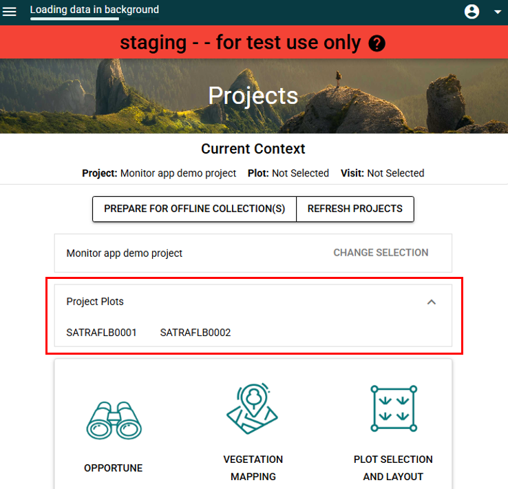
To see a list of the plots created for your project, on the projects page select the arrow on the right of the project plots box above the module icons (see the screenshot below). If you prefer you may view your plots on a map via the MERIT website.
Yes. The plot location reference point set during the Plot selection protocol is only a guide for where to position the plot based on a desktop survey. This location is ground-truthed and can be changed while completing the Plot layout and visit protocol.
The actual plot location is captured in the Plot layout and visit protocol, Plot layout step, by selecting the start plot layout button. This will bring up the map showing the recommended plot location (orange dot) selected in the Plot selection protocol. If this is not the exact location you want to layout the plot then you can set it somewhere else by standing at the desired location (blue dot) and selecting the set reference point button at the bottom of the map page. This will bring up the yellow boundary and points to indicate where the plot will fall. You can use the reset the button to change the plot location at this point.
Only once the plot layout has been completed successfully and the collection submitted is the location final.
The 'context' is displayed at the top of the Monitor projects page and is the specific combination of the project, plot and plot visit. When any of these 3 things are changed, the plot context changes. As data collected is tied to a specific plot context, changing the plot context when an open survey has not been completed and queued for submission and then attempting to continue the survey may result in a context error. For this reason it is important to check that you are in the correct context prior to beginning a survey.
If your map is not visible it may be due to slow loading speeds of map tiles or a limitation of map tiles being stored in Monitor. You are more likely to experience slow map loading in remote areas.
When Monitor loads a map, the tiles are loaded at each level of zoom, which you can determine by the scale in the bottom right. Monitor will store a local cache of these tile files as each one is loaded, but this is device specific. Therefore, if you take some time while online and before going into the field to load each zoom layer of your plot and surrounding area then you should still be able to access these map tiles in the field, provided that it is on the same device.
It does not matter what module or protocol the map layers are initially loaded in, they can be viewed in any module or protocol after this. e.g., load tiles while doing Selection but then view them later in Opportune. Only the tiles visible on the screen when loading the layers will save, not the layer for the whole map, so at each layer you will need to navigate around the project and plot area to ensure you have enough coverage.
See the learning resources page for a video guide.
Please note that even after completing the steps above you may still encounter slow loading speeds in the field and may need to wait a short time for the map tiles to load.
As your device storage approaches capacity some Monitor app functions may become unavailable. You can free up space on your device by deleting unused apps or files. If you have a stable internet connection, you can free up space in Monitor by syncing queued collections.
When following instructions to free up space DO NOT clear the cashe or clear data for the Monitor app or the internet browser it is installed with (e.g. Chrome). Clearing the cashe or app data may result in data loss relating to your surveys.
For instructions to free up space on your device search for steps relative to your device’s specifications. We’ve listed some of the common ones below.
· Samsung
· Google (for Android in general)
· Microsoft (Windows Desktop)
· Apple (iPhones, iPads, Macs)